Log in
All resources
Create a design
11,720 Free Images of 1876 Map Sheets
bibliothèque nationale de france
map of the circle of the rhineland by sanson
map collection of leibniz-institut für länderkunde
oil on canvas
maps in the library of congress
a map of the british empire in america with the french and spanish settlements adjacent thereto
backs of postcards in curt teich postcard archives
address sides of divided back postcards
postcards published by mid-west map
atlas des anciens plans de paris by imprimerie nationale, 1880 from bhvp
map collection of leibniz-institut für länderkunde
maps of spain by tomas lopez
turgot map of paris, kyoto university library – derivative files
foire saint-germain on old maps
map collection of leibniz-institut für länderkunde
maps of spain by tomas lopez
map collection of leibniz-institut für länderkunde
maps of spain by tomas lopez
national museum of maps and rare books, bucharest
maps by abraham ortelius
map of paris by braun & hogenberg - derivative files
rue des archives (paris)
16th-century maps of the indian ocean
renaissance
old maps of montenegro
old maps of dubrovnik
square knot
knot
atlas des anciens plans de paris by imprimerie nationale, 1880 from bhvp
turgot map of paris, bibliothèque historique de la ville de paris
atlas des anciens plans de paris by imprimerie nationale, 1880 from bhvp
turgot map of paris, bibliothèque historique de la ville de paris
atlas des anciens plans de paris by imprimerie nationale, 1880 from bhvp
turgot map of paris, bibliothèque historique de la ville de paris
atlas des anciens plans de paris by imprimerie nationale, 1880 from bhvp
turgot map of paris, bibliothèque historique de la ville de paris
map of paris by jouvin de rochefort (boutier 112)
pont de grammont
old maps of the london borough of tower hamlets
maps by john pine
old maps of the tuamotus
old maps of polynesia
old maps of the principality of minden
1840s maps of north rhine-westphalia
a map of the british empire in america with the french and spanish settlements adjacent thereto
maps in the library of congress
a map of the british empire in america with the french and spanish settlements adjacent thereto
maps in the library of congress
a map of the british empire in america with the french and spanish settlements adjacent thereto
maps in the library of congress
a map of the british empire in america with the french and spanish settlements adjacent thereto
maps in the library of congress
a map of the british empire in america with the french and spanish settlements adjacent thereto
maps in the library of congress
post-impressionism,expressionism
2003 stamps of georgia
collection drawings and prints from het utrechts archief
maskerade utrecht 1876
renaissance architecture in rome
high renaissance
old submaps of paris 1er arrondissement
paris in the 18th century
maps by thomas kitchin
andrew dury
michel berthaud
léon brisse
prints in the missouri history museum
freighting
michel berthaud
léon brisse
michel berthaud
léon brisse
chromolithographs at boston public library
angels in art
jesus christ between the felons
early netherlandish painting
river thames in london in art
japonisme,realism
africa and its inhabitants, vol. ii
charles eugène perron
1816 portrait engravings of men
1804 paintings
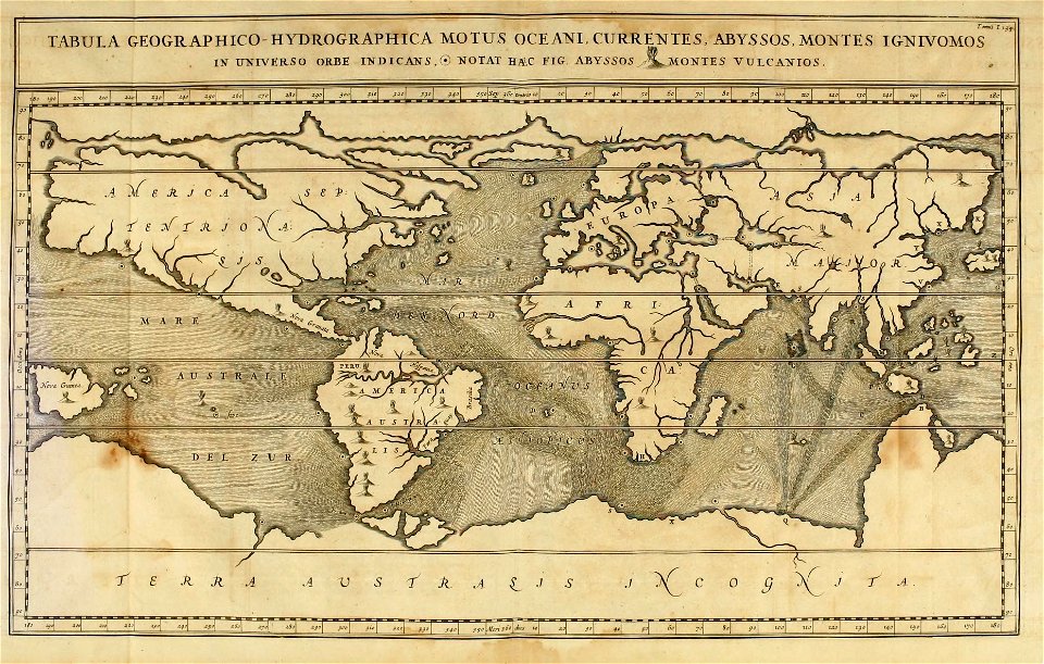
cartes generales de toutes les parties du monde (1658)
1650s maps of saxony
paintings in the art gallery of ontario
impressionism
book pages in the rijksmuseum amsterdam
wildkarspitze (zillertaler alpen)
people of the american library association
1876 portrait photographs of men
1876 paintings by giuseppe de nittis
paintings by giuseppe de nittis
prints in the missouri history museum
edwin forbes
16th-century maps of amsterdam
lodovico guicciardini
géographie illustrée de la france et de ses colonies
orientalist painting
american art and american art collections; essays on artistic subjects (1889)
sarah bernhardt by clairin (1876)
drawings by willem cornelis rip in the rijksmuseum amsterdam
1876 in rotterdam
john rocque's 1746 map of london
details of old maps of london
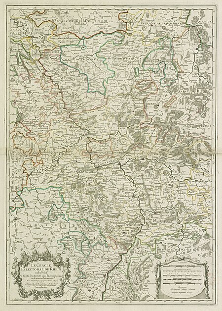
map of the circle of the rhineland by sanson
1670s maps of rhineland-palatinate
map of the circle of the rhineland by sanson
1730s maps of rhineland-palatinate
map of the circle of the rhineland by sanson
1680s maps of rhineland-palatinate
map of the circle of the rhineland by sanson
1730s maps of rhineland-palatinate
map of the circle of the rhineland by sanson
1730s maps of rhineland-palatinate
map of the circle of the rhineland by sanson
1700s maps of rhineland-palatinate
map of the circle of the rhineland by sanson
1700s maps of rhineland-palatinate
map of the circle of the rhineland by sanson
1730s maps of rhineland-palatinate
map of the circle of the rhineland by sanson
1680s maps of rhineland-palatinate
historical images of genoa by francesco ciappei
historical images of the harbour of genoa
backs of postcards in curt teich postcard archives
postcards of ottawa county, oklahoma
nypl collection of atlases, gazetteers, guidebooks and other books
nypl lionel pincus and princess firyal map division
backs of postcards in curt teich postcard archives
postcards of st. louis, missouri
lawrence h. slaughter collection of english maps, charts, globes, books and atlases
nypl lionel pincus and princess firyal map division
mythological paintings by hans thoma
1876 paintings
hippopotamus amphibius in art
hunting in art
1876 paintings
hans haag
book covers from the united kingdom
pre-raphaelite brotherhood
josef von jablonsky del monte beroco
generals of austria
1870s still-life paintings
impressionism
john rocque's 1746 map of london
details of old maps of london
backs of postcards in curt teich postcard archives
postcards of madison county, illinois
backs of postcards in curt teich postcard archives
postcards of creek county, oklahoma
backs of postcards in curt teich postcard archives
postcards of ottawa county, oklahoma
old submaps of paris 5e arrondissement
porte saint-victor (paris)
maps by willem and johannes blaeu
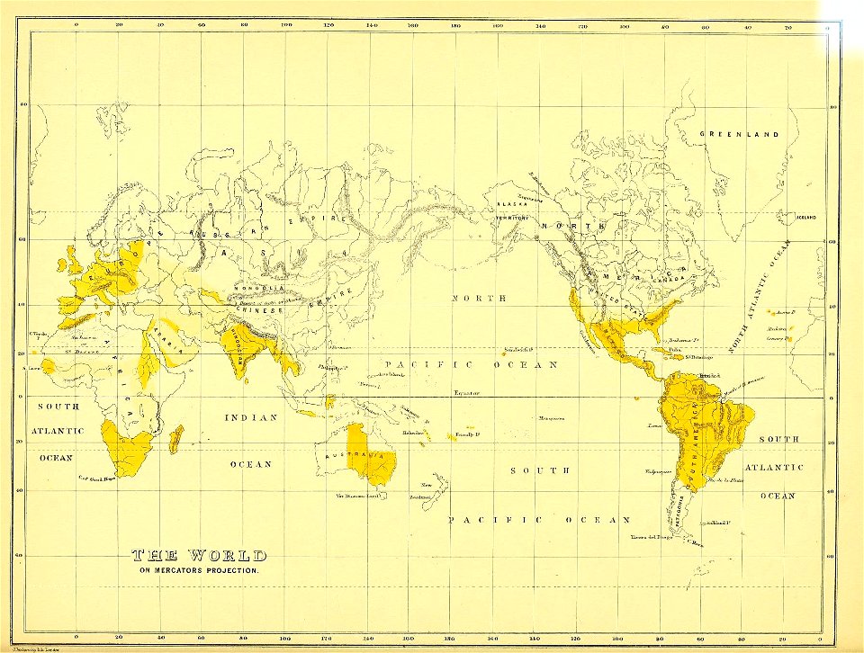
old maps with mercator projection
sheets of stamps of russia, 2007
romanticism
19th-century maps of bohemia
maps of regions of bohemia
curt teich postcard archives, curt teich & company
map postcards
ferapontov monastery
dionisius
japonisme,realism
1877 paintings
william edward atkins
the graphic 1883
konstantin konstantinovich of russia in 1896
portrait paintings after photographs
1876 paintings by gustave courbet
realism
1876 paintings by gustave courbet
realism
contact sheets by the ford white house (august 1974)
shirley chisholm
19th-century portrait photographs of men at bust length by militão augusto de azevedo
henrique bernardelli
portrait paintings by antoine pesne
rococo
bird
owl
map of ancient armenia by philippe de la rué
maps of antony's parthian war
charles roberts (wood-engraver)
the graphic 1875
paintings in manchester art gallery
naturalism
paintings in the biblioteca museu víctor balaguer
art works by modest urgell
cartography
maps
sheets of stamps of russia, 2007
realism
1870s landscape paintings from estonia
woldemar friedrich krüger
everett d. graff collection of western americana
maps by g. w. & c. b. colton & co.
arnold van langren map of southwest africa
renaissance
18th-century portrait paintings in military uniforms of the polish-lithuanian commonwealth
józef poniatowski
cambridge
albert
science
geology
paintings by mary vaux walcott in the smithsonian american art museum
unidentified acer (leaves)
genre paintings by vladimir makovsky
socialist realism
6701 - 6800 of 11,720
Next page
/ 118


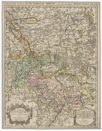
![The Electoral Circle of the Rhine subdivided into all the Estates which compose it... / by Sanson, ,... Geometric Miles or Miles of Italy [30 = 12] common leagues of France, 1734](https://cdn.creazilla.com/illustrations/10001532968/the-electoral-circle-of-the-rhine-subdivided-into-all-the-estates-which-compose-it-by-sanson-geometric-miles-or-miles-of-italy-30-12-common-leagues-of-france-1734-sm.jpg)